Specializing in Low Altitude High Resolution Data Acquisition Surveys
© Copyright 2011 CloudStreet Flying Service
CloudStreet
AirBorne Survey
CloudStreet started business in 1991. The main activities at that time were
ultralight flight instruction, ultralight aircraft sales, maintenance and aero towing
of hang gliders.
In 1996 CloudStreet began flying surveys for Larimer County, Colorado.
Noxious weed control was the issue and the equipment used was video and
Red Hen Systems video mapping hardware/software.
In 1997 CloudStreet started flying surveys for Colorado State University. These
surveys were flown using the Red Hen Systems video mapping technology with
spectral imaging cameras for nitrogen content studies in corn. These surveys
lasted for 3 seasons.
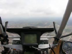
In 1997 CloudStreet began flying remote sensing surveys for Dr. Terry Booth at USDA-ARS High Plains District in Cheyenne, Wyoming. Dr.Booth's research is to monitor rangeland vegetation with Very Large Scale Aerial (VLSA) imagery. These surveys are ongoing and still happening. The ARS surveys have been flown in Colorado, Wyoming, Nevada, Idaho, New Mexico, Oklahoma and North Dakota. For groups such as the BLM, USDA-ARS, The Noble Foundation, the Northern Nevada Stewardship Group, Central Plains Experimental Research Station, Trout Unlimited, Nevada Bighorn's Unlimited and Bitterroot Restoration Inc.. One of the keys to the project is CloudStreet's ability to fly low and slow to obtain high resolution photographs which are not blurred or distorted. The current resolution ability is less than 1mm - 20mm/pixel ground sample distance (GSD). The typical altitude above ground is 300 feet and ground speeds are around 45 mph. There are typically 3 Cannon 1Ds Mark II (21.1 megapixel) cameras of varying focal lengths (up to 800mm) aboard.
In 1998 CloudStreet flew a survey of the Poudre River corridor from the Poudre Canyon to the east side of Greeley, Colorado. This survey was flown with Red Hen Systems video mapping technology for the project to link Fort Collins and Greeley with a bicycle path along the Poudre.
In 2004 CloudStreet began flying mineral exploration surveys under contract with Edcon-PRJ, Inc. of Denver, Colorado. Magnetometer sensing equipment is used. With CloudStreet's ability to fly low and slow, and to gain altitude quickly, we are able to generate very high resolution maps for mineral exploration, oil & gas exploration, geothermal exploration and abandoned oil well location. These surveys are currently the largest part of our business. Exploration surveys have been flown by us in Colorado, Wyoming, Idaho, Utah, Arizona, Texas, Nevada, New Mexico, Oregon, California, Michigan, Illinois, Indiana and Mexico. In one of our more recent (2009)surveys we flew the equivalent of 11,000 miles of survey (including ferry) over 2 states during a period of 3 months.
ultralight flight instruction, ultralight aircraft sales, maintenance and aero towing
of hang gliders.
In 1996 CloudStreet began flying surveys for Larimer County, Colorado.
Noxious weed control was the issue and the equipment used was video and
Red Hen Systems video mapping hardware/software.
In 1997 CloudStreet started flying surveys for Colorado State University. These
surveys were flown using the Red Hen Systems video mapping technology with
spectral imaging cameras for nitrogen content studies in corn. These surveys
lasted for 3 seasons.
In 1997 CloudStreet began flying remote sensing surveys for Dr. Terry Booth at USDA-ARS High Plains District in Cheyenne, Wyoming. Dr.Booth's research is to monitor rangeland vegetation with Very Large Scale Aerial (VLSA) imagery. These surveys are ongoing and still happening. The ARS surveys have been flown in Colorado, Wyoming, Nevada, Idaho, New Mexico, Oklahoma and North Dakota. For groups such as the BLM, USDA-ARS, The Noble Foundation, the Northern Nevada Stewardship Group, Central Plains Experimental Research Station, Trout Unlimited, Nevada Bighorn's Unlimited and Bitterroot Restoration Inc.. One of the keys to the project is CloudStreet's ability to fly low and slow to obtain high resolution photographs which are not blurred or distorted. The current resolution ability is less than 1mm - 20mm/pixel ground sample distance (GSD). The typical altitude above ground is 300 feet and ground speeds are around 45 mph. There are typically 3 Cannon 1Ds Mark II (21.1 megapixel) cameras of varying focal lengths (up to 800mm) aboard.
In 1998 CloudStreet flew a survey of the Poudre River corridor from the Poudre Canyon to the east side of Greeley, Colorado. This survey was flown with Red Hen Systems video mapping technology for the project to link Fort Collins and Greeley with a bicycle path along the Poudre.
In 2004 CloudStreet began flying mineral exploration surveys under contract with Edcon-PRJ, Inc. of Denver, Colorado. Magnetometer sensing equipment is used. With CloudStreet's ability to fly low and slow, and to gain altitude quickly, we are able to generate very high resolution maps for mineral exploration, oil & gas exploration, geothermal exploration and abandoned oil well location. These surveys are currently the largest part of our business. Exploration surveys have been flown by us in Colorado, Wyoming, Idaho, Utah, Arizona, Texas, Nevada, New Mexico, Oregon, California, Michigan, Illinois, Indiana and Mexico. In one of our more recent (2009)surveys we flew the equivalent of 11,000 miles of survey (including ferry) over 2 states during a period of 3 months.